Property Record
179 Sheraton Dr, Salem, VA 24153


Save to a Folder
{{folder.Name}}
{{folder.ListingIds.length}} Properties
{{folder.ListingIds.length}} Property
Create a New Folder
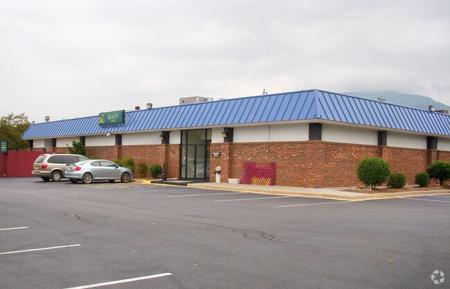
Property Detail
179 Sheraton Dr
4-1-1
TRACT 1A 4.378 AC RESUBD FOR CORDIAL HOSPITALITY LLC
Hotelormotel
Salem
HBD
Virginia
B and X Area of moderate flood hazard, usually the area between the limits of the 100-year and 500-year floods.
4.38 AC
0
Roanoke
2025
Roanoke
010100
Roanoke, VA
71,089 SF
NEARBY LISTINGS FOR SALE OR LEASE
-
-
View all Salem listings for sale on LoopNet.com
DEMOGRAPHICS near 179 Sheraton Dr
1 mile
3 mile
5 mile
2025 Total Population
2,825
31,610
86,478
2030 Population
2,887
31,900
86,795
Pop Growth 2025-2030
+ 2.19%
+ 0.92%
+ 0.37%
Average Age
41
41
41
2025 Total Households
1,126
12,517
35,822
HH Growth 2025-2030
+ 2.31%
+ 0.96%
+ 0.34%
Median Household Inc
$69,602
$64,111
$60,782
Avg Household Size
2.50
2.30
2.30
2025 Avg HH Vehicles
2.00
2.00
2.00
Median Home Value
$245,430
$240,897
$243,270
Median Year Built
1975
1969
1967
Nearby Places
Map Layers
Map Styles
 Street
 Aerial
Layers
 Traffic
 Biking
Places
Listings with unknown addresses are not visible on the map
- Restaurants
- Banks
- Shops
- Fitness
- Groceries
PUBLIC TRANSPORTATION
COMMUTER RAIL
Drive
Walk
Distance
15 min
9.2 mi
AIRPORT
Roanoke/Blacksburg Regional (Woodrum Field)
Drive
Walk
Distance
Roanoke/Blacksburg Regional (Woodrum Field)
15 min
6.8 mi
Nearby Properties
Address
Land Use
TOTAL SIZE
Lot Size
Zoning
Address
Land Use
TOTAL SIZE
Lot Size
Zoning
3,850 SF
60.20 AC
INPUD
Address
Land Use
TOTAL SIZE
Lot Size
Zoning
81,148 SF
52.04 AC
CUDRSF
Address
Land Use
TOTAL SIZE
Lot Size
Zoning
49,887 SF
2.28 AC
C1
Address
Land Use
TOTAL SIZE
Lot Size
Zoning
69,831 SF
73.54 AC
HBD
Address
Land Use
TOTAL SIZE
Lot Size
Zoning
20,646 SF
23.33 AC
R2
Address
Land Use
TOTAL SIZE
Lot Size
Zoning
155,000 SF
3.78 AC
CUD
Address
Land Use
TOTAL SIZE
Lot Size
Zoning
83,167 SF
9.75 AC
C1
Address
Land Use
TOTAL SIZE
Lot Size
Zoning
181,455 SF
6.24 AC
RMF
Address
Land Use
TOTAL SIZE
Lot Size
Zoning
67,903 SF
11.96 AC
I2
Address
Land Use
TOTAL SIZE
Lot Size
Zoning
76,280 SF
9.51 AC
CUD
Address
Land Use
TOTAL SIZE
Lot Size
Zoning
120,584 SF
9.41 AC
HM
Address
Land Use
TOTAL SIZE
Lot Size
Zoning
123,651 SF
29.38 AC
R2S
Address
Land Use
TOTAL SIZE
Lot Size
Zoning
65,428 SF
34.05 AC
C1
Address
Land Use
TOTAL SIZE
Lot Size
Zoning
7,590 SF
14.18 AC
RMF
Address
Land Use
TOTAL SIZE
Lot Size
Zoning
442,530 SF
40.32 AC
HM
Address
Land Use
TOTAL SIZE
Lot Size
Zoning
100 SF
60.09 AC
RSF
Address
Land Use
TOTAL SIZE
Lot Size
Zoning
12,018 SF
8.78 AC
RMF
Address
Land Use
TOTAL SIZE
Lot Size
Zoning
106,884 SF
16.20 AC
R1S
Address
Land Use
TOTAL SIZE
Lot Size
Zoning
74,712 SF
2.13 AC
DBD
Address
Land Use
TOTAL SIZE
Lot Size
Zoning
72,042 SF
7.18 AC
C2
Address
Land Use
TOTAL SIZE
Lot Size
Zoning
100,915 SF
13.80 AC
HM
Address
Land Use
TOTAL SIZE
Lot Size
Zoning
23,600 SF
24.55 AC
LM
Address
Land Use
TOTAL SIZE
Lot Size
Zoning
9,021 SF
8.90 AC
RMF
Address
Land Use
TOTAL SIZE
Lot Size
Zoning
107,815 SF
19.84 AC
CLS
Address
Land Use
TOTAL SIZE
Lot Size
Zoning
55,503 SF
9.69 AC
HBD
Address
Land Use
TOTAL SIZE
Lot Size
Zoning
5.76 AC
RMF
Address
Land Use
TOTAL SIZE
Lot Size
Zoning
103,770 SF
2.08 AC
HBD
Address
Land Use
TOTAL SIZE
Lot Size
Zoning
13,323 SF
4.31 AC
RM-2
Address
Land Use
TOTAL SIZE
Lot Size
Zoning
68,976 SF
1.77 AC
DBD
Address
Land Use
TOTAL SIZE
Lot Size
Zoning
63,192 SF
3.50 AC
HBD
The World's #1 Commercial Real Estate Marketplace
Connect with us
© 2026 CoStar Group
The information above has been obtained from sources believed reliable. While we do not doubt its accuracy we have not verified it and make no guarantee, warranty or representation about it. It is your responsibility to independently confirm its accuracy and completeness. Any projections, opinions, assumptions, or estimates used are for example only and do not represent the current or future performance of the property. The value of this transaction to you depends on tax and other factors which should be evaluated by your tax, financial, and legal advisors. You and your advisors should conduct a careful, independent investigation of the property to determine to your satisfaction the suitability of the property for your needs.